[Name] [ID] [County] [City] [Elevation]

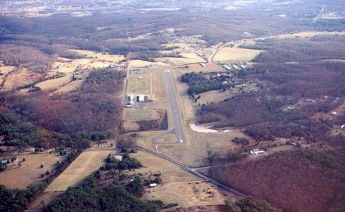
Front Royal-Warren County Airport


Photo by Jim Kellett
Copyright 2001, Jim Kellett, All Rights Reserved

Do you have an aerial photo of this airport?

Airport Details
Elevation:709 feet
Latitude:38ø55'02"N
Longitude:78ø15'13"W
Nearest City:Front Royal
County:Warren
Sectional Chart:Cincinnati/Wash
Navaids, Frequencies, etc.:AirNav FRR
Notes:
Left Hand. Frequent glider operations, gliders use right hand pattern.

Diagram from the 1998 Virginia Directory

1

Accomodations, Hotels, etc.

Chester House Inn
Guest House
(540) 635-1411
Killahevlin Bed & Breakfast
(800) 847-6132
Woodward House
(540) 635-7010

Attractions

Belle Boyd Cottage
Bing Crosby Stadium
Shenandoah National Park
Skyline Caverns
Skyline Drive
Warren Rifles Confederate Museum

Businesses

Blue Ridge Helicopter
CassAviation
(540) 635-3570
Skyline Soaring

Organizations

Chamber of Commerce, Front Royal and Warren County
(800) 338-2576
Civil Air Patrol, Front Royal Cadet Sq.
Meets at Front Royal Airport on Thursdays at 1900.
(540) 869-5662

Restaurants

Dean's Steak House
(540) 635-1780
Grapevine
(540) 635-6615
Stadt Kaffee
(540) 635-8300

Enhance your exposure on Virginia Aviation Online

Unless otherwise specified, all text, html, sql and photographs are Copyright 1994-2008, John S. Huggins.
No part of this site shall be reproduced without the express written permission of the author.
Questions, comments and corrections are VERY welcome! Send them to the webmaster at: john@flyvirginia.com.